Key findings
- Climate change is likely to increase water stress and nutrient concentrations in Lake Beysehir in the future.
- Projected decreases in run-off, reduced precipitation and increased evaporation around 2030 and 2060 suggest that water levels will drop in Lake Beysehir in the future.
- Basin management initiatives which promote reductions in agricultural fertiliser use and reduce abstraction rates are advised.
Water management issues
The key stressors affecting Lake Beysehir are water abstraction for agricultural irrigation, invasive fish introductions and nutrient loading from agricultural areas. The Mediterranean region in which the Beysehir basin is located, is projected to be significantly affected by future climate changes, particularly precipitation reductions and temperature increases. Climate change is expected to decrease water availability and increase water stress, and have significant impacts on lake ecosystem structure and function. Increased temperatures may trigger changes in phytoplankton blooms, particularly in spring increases in cyanobacteria, which in turn can reduce water quality and drinking water availability. As a result, the key ecosystem services that Beysehir provides to local populations – drinking water, irrigation water, fisheries – may be negatively impacted.
Environmental storylines and scenarios
The MARS study on Lake Beysehir projected the impact of multiple stressors (e.g. from climate change and water abstraction) on the ecosystem services that the basin provides to humans. This was undertaken using three scenarios of future environments. The MARS scenarios forecast environmental changes in the context of three storylines describing future political, economic, social and climatic changes, modelled for ten year periods around both 2030 and 2060.
Fragmented World frames a global situation where countries have little regard for environmental protection; in Beysehir, 30% of forest and 30% of cropland is turned into scrubland, and there is a 30% increase in both fertiliser use and water abstraction. Climate change is significant (RCP 8.5). Consensus World has economic growth and environmental protections similar to present day, in Beysehir, 5% of forest becomes shrubland, whilst fertiliser use is reduced by 20% and water abstraction by 10%. Climate change is moderate (RCP 4.5). In Techno World, economic growth is prioritised and environmental management is typically ad hoc, and focused on instrumental gains such as flood and drought protection. In this scenario, 20% of forest and 10% of grassland is turned to cropland in the future, and fertiliser use and water abstraction increased by 10%. Climate change is significant (RCP 8.5). Whilst each scenario is a broad-scale approximation, their use in modelling provides a range of possible future trajectories to inform management and policy decisions. In addition to these scenarios, a baseline for the period 2006-2015 was modelled for reference and validation.

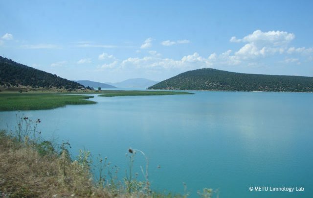
Reed development along the shores of Lake Beysehir

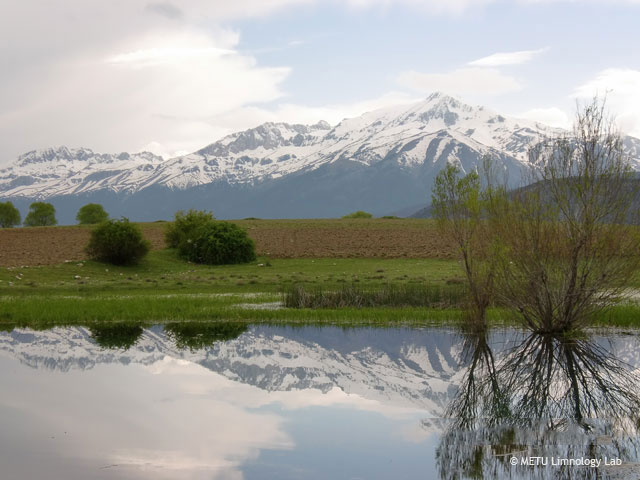
Lake Beyşehir is primarily fed by waters from the Sultan and Anamas mountains
Results and conclusions
Scenario Analysis
Although there is variation among the scenarios, climate change is likely to increase water stress and nutrient concentrations in Lake Beysehir in the future. Hydraulic loading (i.e. the amount of water reaching the lake) decreased in most scenarios, except those with moderate climate change (RCP 4.5), in which it increased due to higher precipitation. The magnitude of decreases in both the amount of water and nutrients entering the lake were highest in the 2060s period. However, despite lowered nutrient loading, in-lake phosphorus concentrations increased for both time periods, with the magnitude of increase highest in the 2060s. Nitrate projections varied between models. Chlorophyll concentrations increased slightly, and cyanobacteria biomass increased significantly in future scenarios, despite reductions in nutrient loading.
Ecosystem services
Decreases in run-off, reduced precipitation and increased evaporation in both modelled periods (2030s and 2060s) in most scenarios suggest that water levels will drop in Lake Beysehir in the future. For the 2060s period, the water level drop is below the minimum management level (possibly even drying out), which is likely to reduce the water available for irrigation, and alter lake ecosystem dynamics. The resulting increases in nutrient concentrations in the lake increase the risk of eutrophication and toxic algal blooms, which is likely to negatively impact drinking water quality, the ecological health and status of the lake, and its recreational value.
Significance for water management
Despite reductions in nutrient loading in the modelled 2030s and 2060s periods, both chlorophyll concentrations and cyanobacteria biomass are projected to increase. When coupled with increasing air and water temperatures this is likely to mean increased risk of eutrophication events. Climate modelling studies from other temperate lakes show that substantial reduction in nutrient loads is needed (~75% in nitrates and 40-50% in phosphorous) to prevent the phytoplankton blooms (Trolle et al., 2008). Basin management initiatives which promote reductions in agricultural fertiliser use and reduce abstraction rates are therefore advised.
In the moderate (RCP 4.5) climate change scenario, high levels of ‘flushing’ (i.e. water flows and mixing) lead to low cyanobacteria biomass levels. Similarly, in the Consensus World scenario, efficient irrigation and lower water abstraction lead to higher water levels and yields, compared to the other scenarios. As a result, the promotion of adaptation measures such as drought-resistant crops and the use of efficient irrigation technologies is important in mitigating the effects of future climate change in the basin.
Basin overview
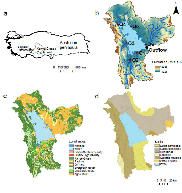
Lake Beysehir is a shallow (5m mean and 9m maximum depth) lake in south-west Turkey. It is both the largest freshwater lake (650 km2) in the country, and in the Mediterranean basin. It is an oligo-mesotrophic ecosystem with low-to-medium primary productivity. It is fed by waters in the Sultan and Anamas mountains, and surrounding limestone springs, with a total catchment size of 4,704 km2 The western part of the lake has a karstic geology, making ground and surface water interactions important. The lake borders two national parks, is both a BirdLife Important Bird Area and PlantLife Important Plant Area, and supports populations of four endemic fish. Lake Beysehir is an important source of drinking water for the district, and for agricultural irrigation in the (largely arable) Konya Basin, which is channeled via a drainage canal.
Context for modelling
The MARS team used an ensemble approach by linking catchment model outputs to two different lake models (GLM-AED and PCLake) to simulate the effects of multiple stressors on ecosystem services in Lake Beysehir. The effects of land use on hydrological processes in the catchment were simulated used a Soil and Water Assessment Tool (SWAT), which was calibrated for accuracy using historical datasets. GFDL-ESM2M and IPSL-CMA-LR climate models were used to generate precipitation and temperature scenarios, using the periods 2006-2015 for verification, and 2025-34 and 2055-64 for forecasting. The effects of future land use and climate changes on key ecosystem services – drinking water and irrigation water – were evaluated by using indicators of water level, phosphorous, nitrates, chlorophyll, and cyanobacteria biomass in the modelling process.
Materials and methods
Land use data were obtained from the Corine 2006 database; soil type definitions from the Harmonized World Soil Database; soil hydrological and physical parameters were derived from soil texture data using the Hypres model. Agricultural management was defined through data obtained from local authorities and the Turkish Statistical Institute. The Penman-Monteith method was used for estimating potential evapotranspiration, and surface runoff was calculated using the U.S. Soil Conservation Service curve number procedure. Meteorological data was compiled from the Turkish State Meteorological Service for the period 1960-2012.
Facts and Figures: BEYSEHIR
- Contact person: Meryem Beklioglu; Middle East Technical University Ankara (METU)
Further reading
MARS Deliverables:
MARS (2017) Case Study Beysehir - Case Study Synthesis - Deliverable 4.1. (Download report, 26.1mb)
Scientific articles and reports:
Bucak T., Trolle D., Andersen H.E., Thodsen H., Erdoğan Ş., Levi E.E., Filiz N., Jeppesen E. & M. Beklioğlu (2017). Future water availability in the largest freshwater Mediterranean lake is at great risk as evidenced from simulations with the SWAT model. Science of The Total Environment (online). (Read abstract)
Levi E.E., Bezirci G., Çakıroğlu A.İ., Turner S., Bennion H., Kernan M., Jeppesen E. & M. Beklioğlu (2016). Multi-proxy palaeoecological responses to water-level fluctuations in three shallow Turkish lakes. Palaeogeography, Palaeoclimatology, Palaeoecology, 449, 553-566. (Read abstract)
Trolle D., Jørgensen T.B., & E. Jeppesen (2008). Predicting the effects of reduced external nitrogen loading on the nitrogen dynamics and ecological state of deep Lake Ravn, Denmark, using the DYRESM–CAEDYM model. Limnologica-Ecology and Management of Inland Waters, 38(3), 220-232. (Read abstract)
Websites:
Freshwaterblog (2017). Largest freshwater Mediterranean lake may dry out in this century due to climate change and abstraction (External website)
Freshwaterblog (2016). Lakes are vanishing across the world (and some may never return),(External website)
Freshwaterblog (2014). Meet the MARS Team: Tuba Bucak (External website)


